Tinh Yen Bai Holiday Weather today
Date/time of update: April 22, 2025, 12:58 am, Timezone: GMT+7
Scattered Clouds
Temperature: 26.89°C
Temperature feels like: 28.52°C
Minimum Temperature: 26.89°C
Maximum Temperature: 26.89°C
Atmospheric pressure: 1010hPa
Humidity:68%
Visibility: 10000m
Wind speed: 1.05m/sec
Wind Direction: 82 degrees
Cloudiness: 27%
Sunrise: 2025-04-21 10:36:33
Sunset: 2025-04-22 11:22:50
It was Thursday and I was getting funky again. The weather seemed to have changed last night with new rounds of monsoons which made temperatures drop and the air fresh. The breezes were so gentle and the air was dry. This kind of breezes is called “Heo May” in Vietnamese.
Travel Guide to Photography Tours in Yen Bai Vietnam
Normally “Heo May” appears mostly in the time between autumn and winter in northern Vietnam. “Heo May” breezes make the air a bit chilly, dry and fresh; on a day of “Heo May”, the sun shines gently which makes us feel very comfortable. “Heo May” comes along with beautiful weather that has come into Vietnamese literature and poetry...

Rice field and palm forest at Doan Hung Phu To
Day1: Hanoi – Doan Hung (Phu Tho) – Yen Bai City – Nghia Lo Town
I felt so pleasant and called my buddy to see how things were going. He was ready. We went out for some coffee without being in a hurry. It'd be such a waste to be in a hurry on such a beautiful day. We started to get rolling out of the city in late morning, around 09:30 A.M or something. The air was fresh, so we turned down the car windows to let the fresh air in while leaving Ha Noi. It was a bit cooler as we were out of the city. The scene was just so beautiful with green rice paddies and dark blue mountains. The city seemed to be hugged by 2 ranges of mountains: one is called Ba Vi and the other is called Tam Dao, both are hill stations and home to amazing national parks. I'd write more about these two national parks at another time...
It was always exciting to travel again. We had been working on a special trip for 10 photographers who wanted to capture the most beautiful scenes of Vietnam. North-West of Vietnam was an indispensable part of the trip, but 6 photographers in the group had taken the North West of Vietnam with us already and they wanted something new, off-the-beaten track. Normally traveling in the North-West of Vietnam would mean to take the route via Road No. 6 via Hoa Binh Mai Chau, Son La – Dien Bien Phu and the from Dien Bien Phu – Lai Chau – Sapa – Yen Bai – Ha Noi. So it was easy, we'd take a different North-West of Vietnam then, this time we'd focus more on the beauty of Yen Bai Province. I asked one of my buddies, Thanh, to come along on our inspection trip to Yen Bai. Thanh is an amateur photographer and he had got many adventures to the far-flung regions of the country. He was surely to know what would be best for a photographer.
We followed Road No. 32 from Hanoi to Phu Tho and Yen Bai Province via Road No. 32. The road was in excellent conditions and traveling on the road had never been such easy. After passing Trung Ha Bridge linking the former Ha Tay Province and Phu Tho Province, we took the route along the Red River to Yen Bai. The scenery along the river was so spectacular with orchards of bananas, papayas...Local farmers set up stalls all along the road to sell seasonal fruits to passers-by...
Phu Tho is basically part of the Red River Delta and the scenery is similar to other areas near Hanoi: vast green paddy fields dotted with white conical hats. We didn't stop much for photos as we wanted to save time for Yen Bai. As we traveled closer to Yen Bai, the scene changed quickly. The roads amid villages and paddy fields turned out to be traveling through low-hill areas flanked by thin forests. There were narrow valleys of rice paddies and palm forests alternated by eucalyptus forests. There was lots of logging going on in the area. They were planted forests after all and they needed materials for the paper factories somewhere I guessed. Still there was a weird feeling about logging in me: I was wondering how the government could administer the logging efficiently then?
After brief lunch at Cat Lem Town of Doan Hung District, the road branched out and we took the one to Yen Bai. I felt sleepy on the road which seemed to me in great shape. There road system in Vietnam has been improved a lot in the last 10 years. It's just a good thing for developing the economy and it's great for travelers to come and see the country. Many communities are benefiting from this...
When we had passed Yen Bai City the road was more uphill and we found hills covered with green tea terraces all along the way. There were not many villages along the road. I felt a bit cool and was awakened...We stopped and got out of the car for stretching our legs. It was so quiet and fresh outside. The road had hardly any traffic on it for most of our journey from Yen Bai to Nghia Lo. The gradients were steep sometimes, but all were in good conditions and the driver found no difficulties navigating the way.
We entered Van Chan District in late afternoon and the road started to get flat. There were more tea plantations and tea factories along the way. There were more communities in the area, so there were more economic activities here. Basically people of Yen Bai earn their money from the forests, from the tea plantations and the tea factories. There are a few tea factories that provide quite famous tea brands in Vietnam which are based here.
After passing 5-7km of tea-covered low hills, we traveled further into the central area of Muong Lo Valley, the second biggest flat valley in the North West of Vietnam (after Muong Thanh Valley of Dien Bien Phu). Before entering Nghia Lo Town located right in the central of the valley, we stopped for a rest in the middle of the rice field. All was quiet and it started getting cold. The wind was blowing stronger and the air was so fresh. All around Muong Lo Valley, the mountains were becoming more and more of a dark green color. The rice was recently transplanted and by looking at the colors of the rice plants, I could tell that the roots were starting to develop. The farmers here would get their bumper crop in the next 5 months...
Arriving at Nghia Lo, I asked the driver to make a circle around the town. Things didn't change much compared to my last trip here last year, no new hotels. It took us some five minutes to have a complete tour of Nghia Lo Town before arriving at our hotel, supposed to be the best one available. It's claimed to be a 3-star hotel, but it'd think it's a decent hotel of 1-star one. We were in the one of the most far-flung areas of the country anyway and the important thing was that it was clean. So it was good.
In the evening, Thanh and I went out for dinner and had a walk around the town. It was quiet and people seemed to go to bed early here. There were a couple of cafes with dim colorful light, but we decided to go back to the room and had an early night. The night passed by peacefully...
Day2: Nghia Lo Town – Tu Le Valley – Khau Pha Pass – Mu Cang Chai
I woke up at 4 or 5 A.M by the noise from down the street. It was amazing that the sun woke up very early in this town so did the people. Back in Hanoi it had to be dark still. But it made sense to me, they went to bed early and got up early...I tried to find back my sleep, but it had gone far away I thought, so I put on the shoes and had a walk around town. After a little while, I stopped at a local cafe which looked simple but spotless-clean cafe. The gentleman made beautiful hot black coffee and I thought it was even better than most in Hanoi...Amazing!
When I went back to the hotel, Thanh was in the restaurant and was enjoying his coffee too. We got some time chatting about the program of the day and got back to the room for the check-out. Leaving the hotel at 09:00 A.M, we made our way to Tu Le, 50km from Nghia Lo Town and it took us 1 hour to get there. Tu Le is similar to Lao Chai and Ta Van of Sapa, except that the rice terraces are so beautiful that photographers from Hanoi travel a few hundred kilometers to get here only to take photos of the rice terraces!
Arriving at Tu Le at 10:15 A.M, we had to leave the car and used the motorbike of our friend in town to travel around into the villages. Thanh was busy looking for the right point with best angles to take photos while I was thinking that the photos of the rice terraces are so amazing here. We visited the area at the right time, right after the rice transplanting and the colors of the terraces were just stunning. It took us three hours around the area and it was nearly 13:30. We pulled ourselves to one of the local restaurants and got a simple lunch. The restaurant got a lot of specialty dishes of the town, but we only asked for simple food. We were worn out...

Rice terraces of Tu Le from Khau Pha Pass
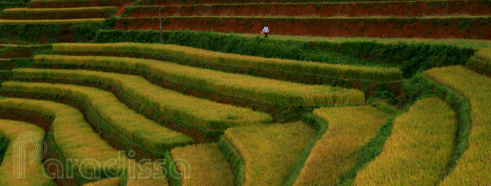
At 14:00, we got into the car and off we made our way out of Tu Le. After some 10 kilometers from Tu Le, we found ourselves climbing the Khau Pha Pass. The Pass is over 2000m above sea level and always covered in fog. Dangerous it may be, but it also offers breathtaking view of the surroundings. Thanh cast a glance back and asked the driver to stop. Looking back at Tu Le Valley, we were dump-founded by the mesmerizing beauty of the fresh nature and of men's works. The rice terraces of Tu Le were so spectacular...Different patches offered different kinds of green colors, they lined side by side and looked so soft just like sheets of water colors! We thought we'd make it to Mu Cang Chai early, but actually spent 3 hours on the road with stop every 3-5 minutes for adoring the the magnificent beauty!

Rice terraces of Tu Le from Khau Pha Pass
Arriving at Mu Cang Chai at twilight, we got straight to the guest house and got early dinner before getting the room. We knew the local people normally had early nights here and didn't want to miss our dinner! After dinner, there was a power failure which gave us a good reason to go to bed early...It was so quiet outside and having enjoyed life so much during the day, I slept straight away...
I woke up at 05:45 A.M thanks to cock a doodle doo sounds. They seemed to be having a race this early morning which blew up the quietness of the mountains. I put on some warm clothes and got my shoes on for a walk around the town. Yes, there were only some ten houses lining one street which ran along a stream. That was Mu Cang Chai Town. The town is over 1000m above sea level and is surrounded by mountains. One the one side, the mountains are covered with beautiful pine forests, on the other side they were stunning rice terraces. I was sure I knew the reason for which so many photographers had made their way on the bad roads and past through high mountains and passes for this little town a few years ago...
Day3: Mu Cang Chai Photography Adventure
Arriving back at the hotel at around 07:30, my buddy got up and was having breakfast. I joined him and talked about the plan for the day. At 08:30 we got a motorbike from the guest house and made our way to the surrounding terraces of Mu Cang Chai. Those at Che Cu Nha, Ze Xu Phinh and La Pan Tan Communes were just stunning. We had to leave to motorbikes sometimes to climb uphill for the best angles. The landscape here was so beautiful that we spend most of the morning making our way amid the terraces. I was thinking that our photographers would have some best pictures of Vietnam from the terraces here...
We got back to the guest house when it was almost 14:00. Our stomach started roaring asking for food. Yes, we deserved some after hard work then. The rest of the afternoon was easy chit-chatting with the ladies in town and coffee. It was a peaceful town, but given the beauty it possessed, I was wondering for how long it would be this peaceful?
Day4: Mu Cang Chai – Than Uyen (Lai Chau) – O Quy Ho Pass – Sapa – Lao Cai - Hanoi
The final day was a long one as we traveled via the Hoang Lien Mountain Range via Sa Pa and made our way back to Ha Noi late in the evening. We were a bit tired, but I was sure I'd come back when the rice ripened to take in the golden rice terraces...
Traveling on the Hoang Lien Mountain Range of Sa Pa, it was so cold and foggy...


