Tinh Lao Cai Holiday Weather today
Date/time of update: April 22, 2025, 12:16 am, Timezone: GMT+7
Few Clouds
Temperature: 19.76°C
Temperature feels like: 19.72°C
Minimum Temperature: 19.76°C
Maximum Temperature: 19.76°C
Atmospheric pressure: 1010hPa
Humidity:74%
Visibility: 10000m
Wind speed: 0.54m/sec
Wind Direction: 185 degrees
Cloudiness: 16%
Sunrise: 2025-04-21 10:38:21
Sunset: 2025-04-22 11:26:22
Mount Bach Moc Luong Tu(officially reverted to its correct name Ky Quan San from April 7th, 2018) straddles Lao Cai and Lai Chau Provinces. The peak of the mountain is 3,046m above sea level and you can climb the mountain from both Lai Chau and Lao Cai.
Travel Guide to the Bach Moc Luong Tu (Ky Quan San) Mountain in Lao Cai and Lai Chau
1/ Routes to the summit from Lao Cai and Lai Chau
The route from Lai Chau is easier and travels through dense forests while the route from Lao Cai is shorter and much harder involving climbing vertical rock cliffs. The latter offers you with sweeping mountain vistas and with plenty of opportunities to take photos of the sublime beauty of the mountains, clouds and valleys and of which the information is provided by Paradissa in this travel guide. 
2/ Best time to climb the mountain
The best time to climb Bach Moc Luong Tu is in the dry season which is from late October through April. It is extremely cold during the winter months (November, December, January) and there is probably snow in the mountain during this time. During November and December, you'll trek amid “an ocean of clouds” with unreal scenery all around. In February and early March there are rhododendron flowers which make the scenery on your trek much more beautiful.

Trekking Bach Moc Luong Tu during rainy times should be avoided as the paths are too slippery, sticky and muddy, it is too dangerous with the sheer rock cliffs that we have to climb up and down especially in raincoat, and above all the views are blocked by thick fog. The photos you have would show you nothing of the stunning mountainscape around.
3/ What the trek to the summit is like?
3.1 Starting at the Ky Quan San Village
An adventure to Bach Moc Luong Tu Peak includes trekking and climbing tour which normally takes 3 full days with one single route up and down. The starting point of the trek is at Ky Quan San Village (Hmong People) which is nearly 1,000m in elevation. You can reach the village from the main road by motorbike.

3.2 Some important notes
And on the first day you are to trek for more or less 7-8 hours to a rudimentary wooden guest house at 2,100m in altitude. So you'd better to start your trek no later than 10:00 A.M during the winter months and 11:00 A.M during the summer months. Else, you'll have some very uneasy time trekking on a tiny, rocky and uneven path in the dark in a dense forest.
Keep in mind that there is no private room with en suite bathroom facilities at the guesthouse here: everyone shares one big room, the bathrooms and toilets are separated from one another and from the sleeping room. There are openings in between the wooden planks which form the walls of the house and the air moves freely in and out. Blankets and pillows are provided and they are certainly not washed for a while, meaning they may have some not so nice smells. There are beds with no mattresses or mosquito nets. The solution would be you bring along your own sleeping bag or put on your warm clothes and insect repellents while in bed.

3.3 Trekking terrain on Day1
The terrain that you'll trek on the first day include 3 parts: the first part is on a narrow path going up slightly through a dense forest for 3 hours, the second path is basically flat with thin forests alternated with corn terraces for 2 hours, the third part is through a jungle with very steep terrain and uneven path for 2 hours. Everyone should surely reserve some strength for the last pull! On the first day, you'll travel through some beautiful waterfalls and streams and the views of the mountains are fabulous.


3.4 Trekking on Day2
The trek on the second day involves a hike through a jungle with terrain going up steeply which is followed by vertical rock cliffs that we have to cling to vines, trees, and tree roots to pull ourselves up the way. Make sure you calculate your steps and the leaning points carefully each time you give it a try through a rock cliff. After this, you'll follow a slightly going up path through a dense forest with low trees to 2,800m. From here you'll have wonderful views of the surroundings on a clear day.

The path from 2,800m to 3,046m is mostly flat on a narrow dirt path via bushes and a thin forest with low trees. Then comes a huge boulder (a very very big one forming a part of the summit!) that you'll have to trek on a tiny path around it to get to a bamboo forest which goes up slightly to the summit. The views are not that spectacular from here compared to other lower points on the way though. On the second day you'll trek for 5 hours to the summit, allowing half an hour on the summit and the descent is about 4 hours. The adventure on the second day could be longer or shorter depending on the weather conditions, your fitness, the time for photography…

Morning at Nui Muoi Mountain (2,100m)

Climbing over a vertical rock cliff on the way to the summit

Stunning mountainscape on the trek

A break after scaling the summit of Bach Moc Luong Tu

Captivating view of Mount Nui Muoi and nearby mountain peaks, the red roof of the guest house at 2,100m

Trees with mosses on the trunk near the summit of Bach Moc Luong Tu

The summit of Bach Moc Luong Tu
3.5 Trekking on Day3
On the third day, you'll descend the mountain from the guest house, or from 2,100m to 1,000m. The trip should take around 6 hours. While going down is not as hard as going up, the uneven and tiny paths make it not easy to do it fast. When it is wet, things are extremely slippery. Paradissa organizes trekking adventures to the summit of Mount Bach Moc Luong Tu (Ky Quan San) for 5 days, 4 nights. On these trips, you'll have 2 nights on the train and 2 nights at the guest house at 2,100m. Please don't hesitate to contact our adventure experts for further information.


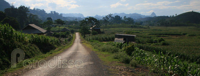
Scenic landscape where the trek to Bach Moc Luong Tu starts


